 quite.space
The Field tab is a map the space keeps together: places, routes, sectors, markers — and people, when they explicitly choose to be on it. It is built for the days when the group is physically somewhere: a hike, a search sweep, a festival camp, an actual search-and-rescue operation.
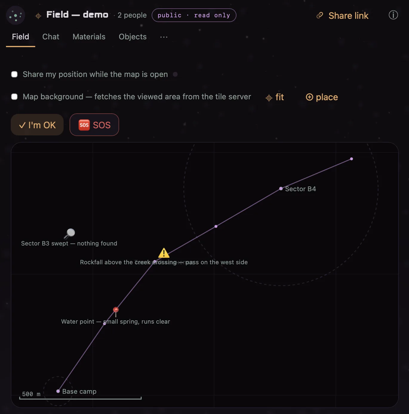
A map of claims, not of facts
Everything on the Field is somebody’s signed statement: “water point — small spring, runs clear”, “rockfall above the pass”, “sector B3 swept — nothing found”. The map does not pretend to know more than that, and the most honest part is how positions age in front of you: live, then stale, then unknown. The alternative would be a map that says somebody is somewhere when all anyone holds is a statement from forty minutes ago — that is how searches go wrong.
- Sharing your position is an explicit act — a switch that says exactly what it does, with a signed expiry. Nobody is tracked by default; presence on the map is something you say, not something that leaks.
- Check-ins — one tap “I’m OK” with a timestamp; the space can set an expectation (“expect check-ins every hour”), and a missed one is visible as exactly that: a missed check-in, not a manufactured location.
- SOS travels on its own lane — it does not queue behind chat, and it looks like nothing else.
Working a search
Markers for what was found and where; sectors for who sweeps what; a swept sector is marked with its result (“nothing found” is a result — it spares the next pair the same ground). Routes record where people actually walked. Every field event fits a single LoRa frame — measured, not assumed — so the same operation works where there is no internet at all, over radio.
Sweeps: recording where you actually went
Since 1.0.0-beta.2 a sector or place offers Start sweep — and this is the one case where recording continues with the screen off, because it is not passive tracking but a bounded session with a visible lifecycle: it begins with your press, a persistent notification names the operation the whole time and carries the Stop that ends it, and without a running session background recording is structurally impossible (the app declares no background-location permission at all).
- Gaps are honest. GPS lost, phone asleep, sparse fixes — the track records each as its own kind of gap, the map draws a gap as a gap, and the GPX export breaks segments in the same places. No line is ever drawn through a forest for the sake of a continuous polyline.
- Kill the app and the recording survives — the session lives in the node; an abandoned sweep finalizes as interrupted with the walked track preserved, and its task stays open.
- The fact travels first. On Stop, a radio-sized completion event (“Sector B3 swept · 13:02–13:47 · 2.7 km · nothing found”) crosses even LoRa immediately; the detailed track follows as an asset when a wider path appears.
- Export — GPX / GeoJSON / CSV projections of the recorded track, for any external analysis.
An observation made on the way can attach one photo as evidence — the note stays radio-sized, the picture follows as media. And a new place is made by a finger on the map: arm, tap, name.
Real maps under it, offline-first
The map background is OpenStreetMap, restyled to the dark, cached encrypted on your device — the places you have looked at keep working with no network. It is off by default, and the switch says why: fetching tiles tells a server which part of the world is on your screen. Your connectivity choice outranks the map — offline means offline, and the Field falls back to its own paper grid rather than to a spinner.
A demo Field ships as a public read-only space — open it from the official catalog, drag the map, read the markers.